Blue Ridge Summit Trail other trails nearby (tap a dot to open it)
Get directions · Google MapsApple Maps
© OpenStreetMap contributors (ODbL) · Full route · OpenStreetMap · Basemap: OpenFreeMap (OpenMapTiles, © OSM contributors).
7-day forecast
Open-Meteo (CC BY 4.0)Best time to hike
Best months: Apr–Jun, Sep–Nov · highs 11–26 °C (52–79 °F)
- J3°-5°91
- F5°-4°89
- M10°0°115
- A16°5°116
- M21°10°123
- J26°15°121
- J28°18°118
- A27°17°109
- S23°14°122
- O17°8°104
- N11°3°102
- D5°-2°98
Average high °C · low °C · precipitation mm per month. Highlighted: best months.
How we pick months
Best months are those where the 1981–2010 average daily high is 10–27 °C (50–81 °F), the average overnight low is 0 °C (32 °F) or warmer, and average precipitation is 200 mm (7.9 in) or less. Values are long-term monthly averages for the ~1 km cell at the trail point on the map, from CHELSA V2.1 climatologies (Karger et al., CC0), not a forecast. Higher or more exposed parts of a route can be colder, wetter or snowier.
Trail facts
- Mapped length
- 2.8 km · 1.7 mi (OSM route, Waymarked Trails)
- Mountain range
- Northern Blue Ridge (Blue Ridge Mountains › Appalachian Mountains; GMBA)
- Nearest town
- 3.5 km W of Thurmont (Frederick County, Maryland) · GeoNames
- Park or forest
- Catoctin Mountain Park
- Best months
- Apr–Jun, Sep–Nov
- Country
- United States of America
- Region
- Maryland
- Continent
- North America
- Route type
- Local route
- Operator (OSM)
- National Park Service
- Route centre
- 39.6424, -77.4467
- Route start
- 39.6337, -77.4493
- OpenStreetMap
- relation 19072868
- Official info
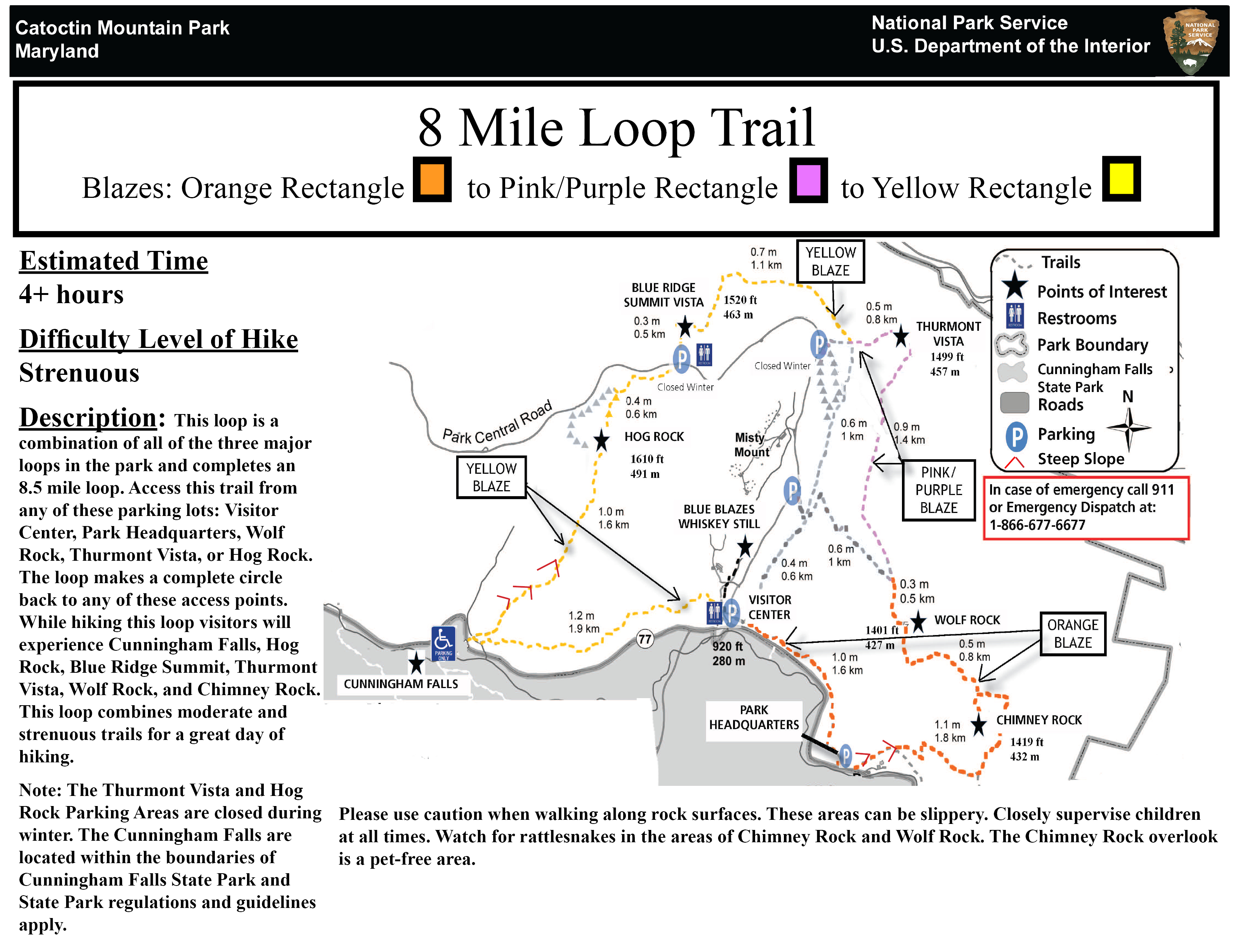
- nps.gov/images/8-mile-Loop-BLaze.jpg
How it’s scored
Hikers can rate difficulty from 1 to 10 (1 = flat, short, easy walk for anyone; 3 = gentle hills, a little effort; 5 = moderate climbs, some fitness needed; 7 = steep or long, solid fitness required; 10 = extremely strenuous or technical; long steep climbing; experienced hikers only). The community average is shown once at least 3 people have rated the trail; until then the official or computed score is used when we have one.
More trails in the Northern Blue Ridge
All 176 →Nearest trails
distance from the trail start8 Mile Loop Trail
0.3 mi · 0.5 km · Catoctin Mountain Park
Old Misery
0.9 mi · 1.5 km · Maryland
Cat Rock Trail
1.3 mi · 2.1 km · Maryland
Social Trail
2.7 mi · 4.4 km · Maryland
Bob’s Hill Trail
2.9 mi · 4.6 km · Maryland
Catoctin National Recreation Trail
4.7 mi · 7.6 km · Catoctin Mountain Park
All trails in Maryland → · All 36,834 trails in United States of America →