7-day forecast
Open-Meteo · trail point · local dates · last updated Nov 11, 2026, 3:10 PM PTThu 12
Heavy snow
-4°C / -8°C
100% · 5.2 mm
Wind 35 km/h
PoorFri 13
Overcast
-4°C / -8°C
9% · 0.0 mm
Wind 25 km/h
GoodSat 14
Heavy snow showers
-1°C / -5°C
100% · 21.5 mm
Wind 23 km/h
PoorSun 15
Heavy snow showers
-1°C / -2°C
99% · 38.1 mm
Wind 14 km/h
PoorMon 16
Snow showers
-2°C / -5°C
65% · 5.4 mm
Wind 8 km/h
FairTue 17
Light snow
-4°C / -8°C
51% · 1.7 mm
Wind 4 km/h
FairWed 18
Fog
-7°C / -11°C
25% · 0.0 mm
Wind 5 km/h
GoodRoute
No route line in this build. No OpenStreetMap route relation is linked for this trail.
About this trail
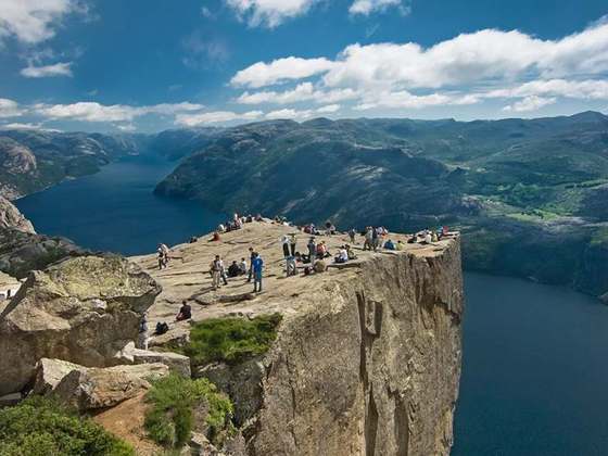
Trolltunga is a rock formation situated at an elevaton of 1,126 metres (3,694 ft) above sea level in Ullensvang Municipality in Vestland county, Norway. The cliff juts horizontally out from the mountain, about 700 metres (2,300 ft) above the north side of the lake Ringedalsvatnet.
From the Wikipedia article “Trolltunga”, CC BY-SA 4.0.
Trail facts
- Countries
- Norway
- Continent
- Europe
- Trail point
- 60.13298, 6.75399 (Wikidata coordinate)
- Wikidata
- Q1512593
- Official info
- trolltunga.com
Hiked it?
Log this hikeAdd a GPX file for the Verified Track badge. The first and last 500 m are trimmed off before anything is measured, and the file itself is not kept.
Photo: “View of trolltunga.jpg” by TerjeN, CC BY 3.0, via Wikimedia Commons (resized).