7-day forecast
Open-Meteo · trail point · local dates · last updated Nov 11, 2026, 3:10 PM PTWed 11
Light drizzle
11°C / 7°C
72% · 1.4 mm
Wind 13 km/h
PoorThu 12
Overcast
8°C / 4°C
0% · 0.0 mm
Wind 15 km/h
GoodFri 13
Overcast
8°C / 3°C
0% · 0.0 mm
Wind 9 km/h
GoodSat 14
Light drizzle
10°C / 6°C
60% · 0.5 mm
Wind 27 km/h
FairSun 15
Drizzle
10°C / 7°C
76% · 5.5 mm
Wind 27 km/h
PoorMon 16
Overcast
7°C / 5°C
29% · 0.0 mm
Wind 24 km/h
GoodTue 17
Light drizzle
7°C / 2°C
61% · 1.5 mm
Wind 30 km/h
FairRoute
Route line © OpenStreetMap contributors (ODbL), simplified. Dot: trail point.
About this trail
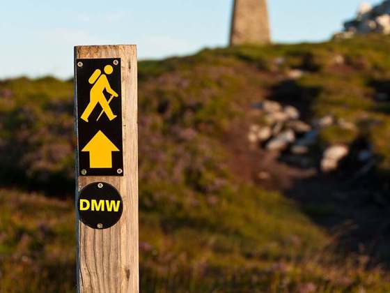
The Wicklow Way is a 131-kilometre (81-mile) long-distance trail that crosses the Wicklow Mountains in Ireland. It runs from Marlay Park in the southern suburbs of Dublin through County Wicklow and ends in the village of Clonegal in County Carlow. It is designated as a National Waymarked Trail by the Irish Sports Council and is waymarked by posts with a yellow "walking man" symbol and a directional arrow. Typically completed in 5–7 days, it is one of the busiest of Ireland's National Waymarked Trails, with up to 24,000 people a year walking the most popular sections. The Way is also used regularly by a number of mountain running competitions.
From the Wikipedia article “Wicklow Way”, CC BY-SA 4.0.
Trail facts
- Length
- 129 km · 80 mi (Wikidata)
- Countries
- Ireland
- Continent
- Europe
- Trail point
- 53.27735, -6.26840 (OpenStreetMap route (first mapped point))
- OSM network
- National walking network
- Operator (OSM)
- Irish National Waymarked Trails
- Wikidata
- Q389539
- OpenStreetMap
- relation 2740
- Official info
- irishtrails.ie/trail/Wicklow-Way/40
Hiked it?
Log this hikeAdd a GPX file for the Verified Track badge. The first and last 500 m are trimmed off before anything is measured, and the file itself is not kept.
Photo: “J B Malone Memorial.jpg” by Joe King, CC BY-SA 3.0, via Wikimedia Commons (resized).